Heavy rain is easing in Southern California, but evacuation warnings are still in place for parts of Los Angeles that face a high risk of mudslides. On Tuesday, a powerful storm system swept across California, bringing intense thunderstorms and record-breaking rainfall.
The affected area includes Pacific Palisades, which was heavily damaged by the wildfire disaster in January.
Los Angeles officials announced Monday night that mandatory evacuations were issued for 114 homes within the broader evacuation warning zone, targeting properties at the highest risk of mudslides or debris flows. Police officers went door to door to notify residents in those vulnerable areas.
The evacuation warning remains in effect until 6 a.m. local time Wednesday for neighborhoods affected by the Palisades, Hurst, and Sunset fires.
Other areas under evacuation warnings include Malibu, Topanga Canyon, Mandeville Canyon, Altadena, and several communities in the foothills of the San Gabriel Mountains.
Mandatory evacuations were also issued for parts of Orange County near the Airport Fire burn area and remained in effect until Tuesday afternoon.
In San Luis Obispo County, officials ordered residents within the Gifford and Madre Fire burn scars to shelter in place.
The National Weather Service explained that ash from wildfires creates burn scars — a water-repellent layer that prevents soil from absorbing rainwater, making the area more prone to flash flooding and debris flows.
The San Gabriel Mountains saw rainfall totals exceeding 5 inches, while most areas across greater Los Angeles received between 3 and 5 inches of rain.
Haines Canyon, located in Los Angeles’ Cecenta Valley, led the state’s rainfall totals on Tuesday with 6 inches of rain.
In Burbank, 2.37 inches of rain fell Tuesday, marking the rainiest October day in the city’s history.
Late Tuesday morning, the roof of a movie studio in Burbank collapsed due to the heavy rainfall, FOX 11 Los Angeles reported.
Wind gusts reached hurricane force in Los Angeles County, with Acton recording a powerful 73 mph gust.
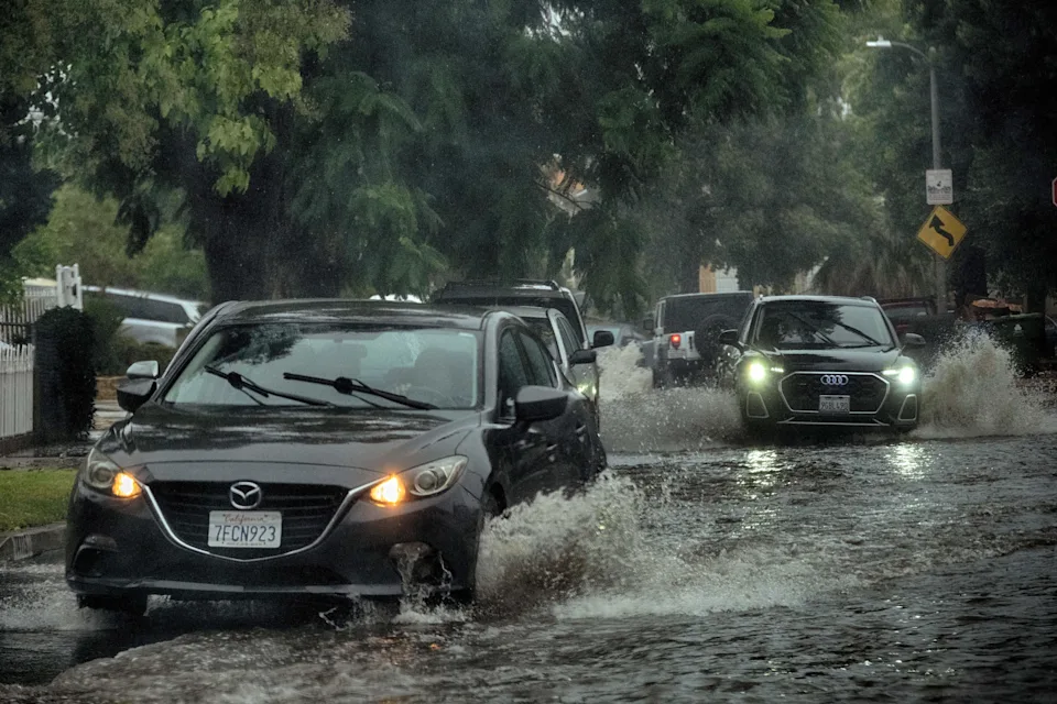
Flash flooding covers major roads
The Pacific Coast Highway in Huntington Beach was closed in the southbound direction due to flooding on Tuesday afternoon, CalTrans reported.
Heavy rain drenched Malibu during the morning rush hour, prompting the City of Malibu to announce the closure of Topanga Canyon and warn drivers about rockfalls in Malibu Canyon.
The northbound lanes of Interstate 5 were also closed due to flooding north of Burbank in Sun City on Tuesday afternoon, though two lanes reopened later in the evening.
A rare Severe Thunderstorm Watch was issued for parts of Southern California, including Los Angeles, through Tuesday morning. It marked the first Severe Thunderstorm Watch for the Los Angeles area in more than 17 years, since January 27, 2008.
The worst of the weather moved north and east of Southern California by Tuesday evening.
Storm Brings Heavy Rain to Bay Area, Snow to Sierra Nevada
The same storm system brought heavy rain to Northern California on Monday, soaking areas across the San Francisco Bay Area.
Video from Monday night showed flooding on Interstate 280 near San Jose, which trapped several cars that had to be towed out of high waters.
The same system will also bring snow to the Sierra Nevada mountain range at elevations higher than 6,000 feet, with 2-3 feet of snow expected at the highest peaks. CalTrans closed the Sonora Pass last Friday ahead of the storm.


Leave a Comment